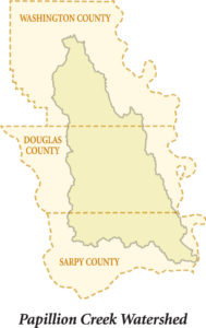
Perhaps the most flood-prone area within the State of Nebraska, the Papillion Creek Watershed consists of 402 square miles and drains heavy rains and snowmelt from much of Douglas, Sarpy and Washington Counties – including the Omaha Metropolitan Area.
There are three primary creeks or tributaries that form the Papillion Creek system – Little Papillion Creek, Big Papillion Creek and West Branch Papillion Creek. Once joined, they form the Papillion Creek that empties its sometimes heavy rainfall runoff load into the Missouri River near Bellevue.
The Omaha Area has long been prone to disastrous flooding . Many times its creeks have overflowed causing tragic loss. An important effort is underway to reduce the risk of flooding and to prevent the considerable loss of life and property that would occur during future flooding events.
Water is Power – The Power of the Papio NRD
Consider these challenges:
- Existing flood control and clean water protection measures within the area are at capacity.
- Urban development is expected to expand across most of the area within the next 30 to 50 years.
- More than 13,000 people would be displaced and property damage could run close to $2.1 billion if Omaha were to experience a flood within the Papillion Creek
Watershed like the flood that struck Ames, Iowa in 2010.
2014 Papillion Creek Watershed Management Plan Summary
It Can Happen Here!
Ames Iowa Comparison to Papillion Creek Watershed:
View the Animations (below)
best viewed full screen
West Branch Papio Creek
Big Papillion Creek
Learn More about this Flood Prone Watershed:
For more Information contact:
Amanda Grint
Water Resources Engineer
402-444-6222
agrint@papionrd.org
Lori Laster, CFM
Stormwater Management Engineer
402-444-6222
llaster@papionrd.org


