Flanagan Lake Officially Opens to the Public

Flood control reservoir provides public safety and recreational opportunities for Omaha citizens

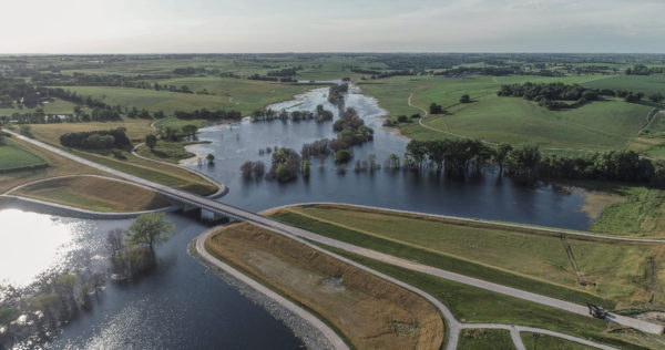
Omaha, NE, June, 27, 2018 – The Papio-Missouri River Natural Resources District and the City of Omaha today celebrated the grand opening of Flanagan Lake, Omaha’s latest flood control reservoir in the Papillion Creek Watershed, that provides flood protection for Omaha citizens and 730 acres of recreational benefits, such as a 220-acre lake, five-mile hiking/biking trail, and park and green space.

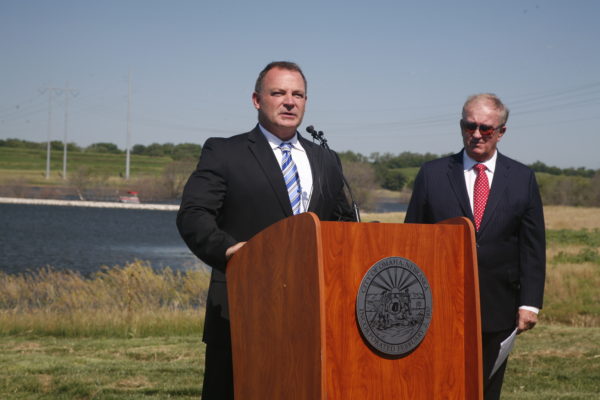
“Flanagan Lake is a reservoir designed to protect the lives and property of Omaha citizens from floods,” said John Winkler, general manager of the Papio-Missouri River Natural Resources District. “This is its primary purpose. The recreational amenities that accompany these types of public safety infrastructure projects are made possible through partnerships. So, it’s flood protection with some incredible cherries on top,” said Winkler.

The $47 million project, located near 168th and Fort Streets, is the largest single flood control structure undertaken by the Papio NRD. It will retain stormwater runoff from an upstream area of approximately 11 square miles. Once the Papio NRD completed construction of the reservoir in 2018, the City of Omaha took over management of the park.

“Just as Father Flanagan created Boys Town to provide a family-centered environment for children, Flanagan Lake is a beautiful public space that will provide family-oriented recreation and leisure,” said Mayor Jean Stothert. “Our excellent parks system provides free entertainment in every part of Omaha. We look forward to opening a Boys Town playground next year, and offering year-round activities for everyone,” said Stothert.

“While the recreational benefits are much more apparent to citizens, providing public safety is Flanagan Lake’s number one job,” said Winkler. “Most people aren’t aware of this. So, as citizens run the trail or kayak the waters, they can do so knowing flood protection is in action while they play.”


To continue the grand opening celebration, Winker also announced the kick-off a city-wide “Dam Fun Contest,” where citizens can enter to win recreation-themed prizes donated by sponsors. For more contest information, visit www.flanaganlake.com.

Additional companies/organizations involved in the design and construction of Flanagan Lake who spoke at today’s grand opening ceremony included HDR, Inc. Vice President & Project Manager John Engel, Nebraska Game and Parks Commission Chairman Dick Bell, Papio NRD Board of Directors Chairman David Klug, and City of Omaha Parks and Recreation Director Brook Bench.

Low-Flying Helicopter – Not to Alarm Public

The Papio NRD and ENWRA (Eastern Nebraska Water Resources Commission) have low-flying helicopter flights taking place in late June and July over Eastern Nebraska to collect and record geologic measurements to learn more about buried aquifers. We want to public to be aware so they will not be alarmed if they see a helicopter mounted with instruments in their area.

Below is a news release from ENWRA with more information.

Eastern Nebraska residents should not be alarmed if they see a low-flying helicopter over areas of the Papio-Missouri River Natural Resources District (P-MRNRD) in June and July.

Beginning in late June and lasting approximately two to three weeks, instruments mounted below a helicopter will collect and record geologic measurements to learn more about buried aquifers (glacial sands and gravels, sandstones and other water-bearing materials).  The P-MRNRD and other members of the Eastern Nebraska Water Resources Assessment (ENWRA), a coalition of six NRDs in the eastern third of Nebraska, have planned the flights with help from the Nebraska Water Sustainability Fund, through the Nebraska Natural Resources Commission.  According to Katie Cameron, coordinator of ENWRA, “The flights will improve our understanding of available ground water and its possible connections with surface water in an area of the state made more complex by the presence of glacial deposits.”

Aqua Geo Frameworks (AGF), of Mitchell, Nebraska will oversee the flights, process data and produce a final report.  The equipment can collect data at a speed of more than 50 miles per hour and explore to a depth of more than 700 feet below the ground surface.  The helicopter will fly over parts of Dakota, Thurston, Burt, Washington, Douglas, and northwestern Sarpy Counties within the P-MRNRD.   Cameron said the flights will be a continuation of ENWRA flights conducted during summer 2016 and will focus with more detail on several areas within the P-MRNRD.  Scientific equipment is towed about 100 feet below the helicopter in a ‘spider web’ array and is designed to map geologic structures beneath the surface of the earth.  The helicopter will be manned by experienced pilots specially trained for low-level flying with this equipment.  Similar flights have been made across Nebraska since 2007, according to Cameron, as NRDs seek to better understand and manage ground water resources.

For more information, please contact:

Contact:
Katie Cameron, PG
UNL Survey Hydrogeologist / ENWRA Coordinator
PH: (402) 476-2729

PH: (402) 419-4798 cell
kcameron_enwra@lpsnrd.org
www.enwra.org


Top