Notice of Explanation of Proposed Activity in a Floodplain

Notice of Explanation of Proposed Activity in a Floodplain

To: All Interested Agencies, Groups, and Individuals

This is to give notices that the Papio-Missouri River Natural Resources District (Papio NRD) has conducted an evaluation as required by Executive Order (11988 and 11990) in accordance with HUD regulations at 24 CFR 55.20 Subpart C Procedures for Making Determinations on Floodplain Management and Wetlands Protection. The activity is funded under the Community Development Block Grant administered by the Nebraska Department of Economic Development Public Works Program.

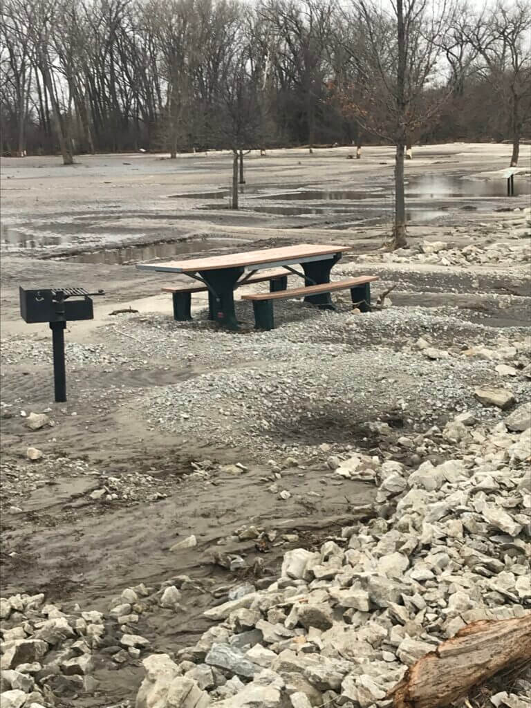
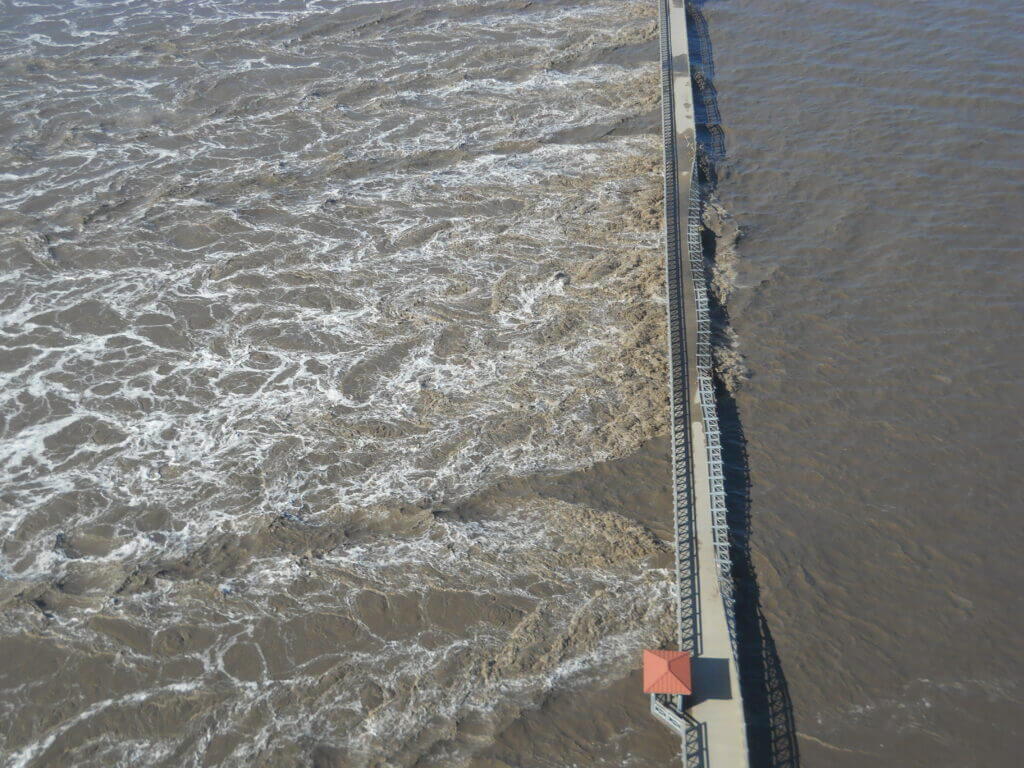
The Papio NRD is preparing to implement a project that involves the removal of rock and sand sediment from the Platte River near the Union Pacific and Burlington Northern Santa Fe Railroad bridges, and on both sides of the Highway 75 and Highway 34 river crossing. The purpose of the project is to restore channel flood capacity. During the 2019 flood event, rock was deposited in the river near the railroad bridges which has resulted in the accumulation of sediment and formation of a sandbar which reduces the capacity of the channel and increases flood risk upstream.

Project activities include removal of buried rock between the two railroad bridges and to the east of the bridges, removal of sand that has accumulated downstream east of the bridges, transportation of the rock to the nearby SID 101 property, deposition of sand sediment in a nearby former NDOT borrow pit, construction and removal of a temporary rock causeway, and clearing and grubbing as necessary for site access.

Project impacts may include temporary road closures, heavy equipment traffic, noise, and dust. Project activities will take place during normal business hours. Total project costs are estimated at $7,945,370, including $100,000 for general administration and $250,000 for construction management. Funding sources include a Community Development Block Grant (CDBG) for $7,150,830 and a match from the Papio NRD of $794,540.

The project will benefit all communities upstream from the current obstruction. Construction will be completed within 4 months of commencement. No persons or businesses will be displaced because of the project activities.

The Papio NRD considered the following four alternatives:

1. No Action Alternative
2. Removing more rock/sediment than was placed by the railroad/has accumulated
3. Removing less rock/sediment than was placed by the railroad/has accumulated
4. Utilizing different construction methods – using equipment below the ordinary high-water mark (OHWM)

The Papio NRD has determined that it has no practicable alternative other than locating the proposed Community Development Block Grant project in a floodplain.

The following mitigation measures will be taken to minimize adverse impacts and to restore and preserve natural and beneficial values:

1. Only the amount of rock deposited during the 2019 event and the sand that has accumulated as a result will be removed as part of this project. Removal of this sand, rock, and accumulated debris will restore channel flood capacity and prevent future flood events from impacting areas upstream. Removal of the rock will alleviate future accumulation of sediment and debris.
2. Erosion prevention measures will be used during construction.
3. Specific timelines will be followed to avoid impacts to threatened or endangered species.
4. Vegetation will be reseeded after construction.

The Papio NRD is both the local sponsor of this project and the local permitting agency for floodplain protection. Therefore, they will ensure all applicable floodplain regulations are met.

This activity will have no significant impact on the environment for the following reasons:

Removal of the deposited rock and accumulated sand and sediment will restore channel flood capacity.

Environmental files that document compliance with steps 3 through 6 of Executive Order 11988 and 11990 are available for public inspection, review, and copying upon request at the times and location delineated in the last paragraph of this notice for receipt of comments.

There are three primary purposes for this notice. First, people who may be affected by activities in floodplains and those who have an interest in the protection of the natural environment should be given an opportunity to express their concerns and provide information about these areas. Second, an adequate public notice program can be an important public educational tool. The dissemination of information and request for public comment about floodplains can facilitate and enhance Federal efforts to reduce the risks and impacts associated with the occupancy and modification of these special areas. Third, as a matter of fairness, when the Federal government determines it will participate in actions taking place in floodplains, it must inform those who may be put at greater or continued risk.

Written comments must be received at the following address on or before June 12, 2024: Janel Kaufman, Houston Engineering, 12702 Westport Parkway Suite 300, La Vista, NE 68138. Janel can be reached via telephone at 402-614-3317. Comments may also be submitted and additional information can be requested via email at jkaufman@houstoneng.com.

A full description of the project may also be reviewed Monday through Friday from 9:00am to 4:00pm at the above address.

Public Encouraged to Start Conserving Water

Below Normal Precipitation and Warmer than Normal Temperatures Will Impact the Platte River

 An Eastern Nebraska group, the Lower Platte River Consortium, is encouraging the public to start now in proactively conserving water. Projections show that warmer temperatures and below normal precipitation are expected to continue through at least May and June.

We all rely on Platte River flows. The Platte River is the lifeline for the state of Nebraska. A majority of the population relies on groundwater from wells, which are replenished by the Lower Platte River, including the communities of Omaha, Lincoln, and Fremont. The Platte River also provides habitat for fish and wildlife, recreation, and recharges wells for irrigation in the Platte River valley.

Weather has a big impact on Platte River flows. Contributing factors include runoff from rainfall within the basin and snowpack in the Rocky Mountains near Denver, Colo., and Laramie and Casper, Wyo. Nebraska has experienced an unusually dry fall and very mild winter, with little snow and rainfall. Current conditions in the state are dry, including lower levels of moisture in the soil.

River flows can decrease to the point where the river will not adequately replenish the wells. Flows in the Platte River are currently adequate to recharge our wells; what those flows will be like later if dry conditions continue is unknown.

Current long-range predictions through May and June indicate above normal temperatures, and below normal precipitation for the state. Dry and warm conditions will have an impact on the amount of water in the Platte River that is available for its various needs and uses.

Given the current dryness, the group asks for the public’s assistance now, knowing it is dry, to use only what you need. If dry conditions persist, the group will communicate this and ask additional assistance from the public to conserve water.

“The consortium will continue to work together to monitor and share information with the public as we progress into these spring and summer months,” states Paul Zillig, General Manager of the Lower Platte South NRD. “Our group recognizes the need to be more proactive and communicate with the public so we can all work together to ensure conservation. We need to start now conserving water, knowing that current long-term forecasts are telling us it’s going to get warmer, and we won’t have much rain.”

The Nebraska Department of Natural Resources has launched an online dashboard available to the public that displays real-time information that the department monitors and collects throughout the state. The dashboard includes current up-to-date drought conditions, common drought indicators, and the streamflow projection for Platte River at Ashland. The data reflects the conditions throughout the Lower Platte basin and the entire state. The dashboard also provides important links to other local and national climate-related resources. The department will continue to closely monitor streamflow conditions throughout the summer.

To view the dashboard, visit the Department of Natural Resources’ site: (dnr.nebraska.gov/water-planning/lower-platte-river-basin).

The Lower Platte River Consortium will continue to monitor the conditions and its entities will work with individuals and communities to conserve water as necessary.

About the Consortium

Formed in 2016, the consortium consists of six different entities (agencies) that monitor and rely on the Lower Platte River for their water supply. These agencies include:

  • Lower Platte South NRD
  • City of Lincoln Water System
  • Lower Platte North NRD
  • Nebraska Department of Natural Resources
  • Papio-Missouri River NRD
  • Metropolitan Utilities District


Current Flooding Normal for This Time of Year

The Papio-Missouri River Natural Resources District wants to reassure the public that minor, lowland flooding that is currently occurring along the Platte River is normal for this time of year. The majority of area rivers are open and free of ice. The current ice jams are also normal and do not, at this point in time, indicate any serious threat like last year.

Of course, the Papio NRD is constantly monitoring river conditions and in continual communication with partners such as the National Weather Service and local emergency managers for any significant changes. We completely understand the public’s concern when it comes to flooding of any amount and want to put current conditions into perspective.


River Access Sites Closed Indefinitely Due to Flooding


Elkhorn Crossing


Sorry folks, we know this is not the news you want to hear.

All of the Papio NRD river access sites will be closed indefinitely due to the recent flooding. These include:

          • Platte River Landing
      • Elkhorn Crossing
      • West Maple Road
      • Graske Crossing

The campground at Elkhorn Crossing Rec. Area will also be closed for the season. Our crews are working as quickly as possible to get the access sites back in shape.

We truly appreciate your understanding.


Lied Bridge Closed to All Users

Lied Bridge

Due to the extraordinary high water during the flood in March, the protective railing on the Lied Bridge over the Platte River has been damaged and the bridge is closed to all users. The Papio-Missouri River NRD is working with the Lower Platte South NRD, and the Nebraska Game and Parks Commission to determine the extent of the damage, and to have repair design and construction moving forward as soon as possible.

Sections of the MoPac Trail under Hwy 50, and from the trailhead parking lot at the west end of Hwy 31 down to the Lied Bridge were also damaged. Signs will be placed to alert users of trail closure. Do not use, or access any section of trail that seems damaged, as the conditions are currently unknown.

Contact the Papio NRD office at (402) 444-6222 if you have any questions about the status of the MoPac Trail or Lied Bridge.


Top